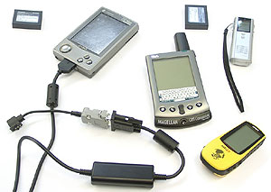
Positioning systems and terrain orientation based on GPS (Global Positioning System) are becoming more affordable and widespread. Scheme of their work is simple: GPS navigation devices receive signals from special satellites, process them and, based on these data, can calculate the current location, speed, its direction. In mid-March had the idea to supply the tourist group, is preparing to make a sports trip in the Polar Urals, several sets of GPS-equipment for testing of the equipment in the Far North. PDAs were kindly provided by MakTsentr, and GPS-receivers by CB-Grad.
Preparation of equipment and software
As a result of the development project was agreed that the keyboard device is unlikely to be used effectively in the field, so we were prepared two sets of GPS-based devices running Palm OS and Windows CE.
Palm OS
Apparatus
In preparation for the campaign had to choose between two options with one common shortcoming manifested itself in different ways. The first GPS-kit consisted of a Palm IIIxe and GPS Rand McNally. In this case, Palm is powered by batteries, and GPS-receiver for some reason the battery, which can not be recharged in the tundra. The second set consisted of a Palm Vx and GPS Rand McNally. Here the situation is quite the opposite - PDA powered by a rechargeable battery, and GPS-receiver battery life. This option seemed more successful, because the battery life battery models Palm, as experience shows, quite long. If the battery charge is not enough, then there are compact devices for battery recharging Palm, for example, batteries Krone. Statistics as a resource storage of GPS-receivers has not been practically none at all, so a variant with Palm III has been dropped.
 |
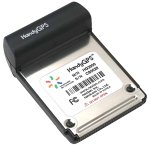
Considered another solution for Palm OS - a bunch Visor + HandyGPS by Nexian a connector Springboard. At first glance, this option seemed to be most successful. Both devices are powered by batteries, a set of fairly lightweight and compact, but ... Unfortunately, HandyGPS does not work with standard protokolomi exchange (NMEA-0182, -0183, etc.) between the GPS-receiver and mapping applications. This device operates within its own protocol, which is only supported special supplement HandyGPS. Thus, the variant with Visor'om dropped.
Among the virtues of the past "qualifiers" Palm OS GPS-kit, we can note a small weight (about 500, with three sets of batteries), small aggregate size. Disadvantages - no quick way to backup the data obtained on the route, the lack of a backup card and the necessary software, as well as quite a long time-selected for the complex GPS-receiver on the operating mode.
Software
For Palm devices there is only one application that allows you to work with raster (scanned) maps using GPS. The software firm Atlas GPS Pilot. The process of preparing maps is fairly simple.With the help of free utilities any scanned image can be transformed into a database for applications Atlas. You can then enter the area and link the card. Moreover, the binding is carried out by two points, and the card must be soorientirovana north. Procedure is quite responsible, because the quality of binding, as you know, depends on the correctness of the entire future of the complex.
 |
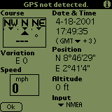 |
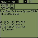
Testing of this complex and the software before sending it we have decided to hold district Taganka. For large-scale maps of the distance between the anchor points were only about 80 m, and that was enough for reliable operation GPS. However, in the process of testing revealed a few unpleasant moments. The main difficulty is to find the point at which the GPS-receiver receives signals from satellites steadily and reaches a reasonable level of accuracy of positioning. Atlas means to determine the moment of the GPS-receiver on the operating mode to bind the card fails. We have to use a small, freeware utility NMEA Monitor, which displays all coming from the GPS-receiver data in raw form.
 |
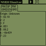 |
The picture shows the beginning of the GPS-receiver. The list shows only two numbers after the equal sign. When their number is four, there is still some tongues, one of which you can see the latitude and longitude values, issued a GPS-receiver. It is necessary to wait until these values are no longer monotonically increasing or decreasing. Once they begin to oscillate around a certain point, we can assume that the GPS-receiver is ready to work. Of course, if the path to the second anchor point GPS-kit does not switch off, then the second time this procedure is not necessary. Another disadvantage is possible to name a few ill-conceived system of working with anchor points, and waypoints. Working with their parameters through an awkward system of windows and menus. For example, the great danger of accidentally deleting a waypoint instead of the entire map. No built-in zoom map: find the right spot on a small PDA screen, especially if the card is great, very difficult. Nevertheless, the Atlas is a definite plus. You can absolutely have no idea of geodesy. Enough to remember some of the action sequences in a program to train in a familiar area, and can safely go into an unfamiliar forest for mushrooms. In addition to display the location on the map Atlas can display speed and direction, altitude, magnetic declination.
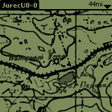 |
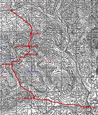
So, found in the Internet map of the Polar Urals was safely passed through the converter and placed in the Palm. For the guys had written a quick tutorial on using Atlas'om.
Windows CE
Apparatus
In the case of Windows CE, it was decided not to philosophize sly and use the already quite well-proven combination of Cassiopeia E-125 and GPS-receiver Garmin eTrex. Both devices allow you to replace the power source (batteries in Cassiopeia and AA batteries for eTrex). Cassiopeia has always been famous for its beautiful color screen and its application in GPS-kit involves the use of colored cards. However, the advantages of color maps is particularly evident in the summer in rich vegetation, and water obstacles areas. In winter, so even in the desert tundra of the Polar Urals, it is possible to do a map in black and white.
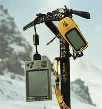 |
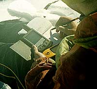
Stability and correctness of the eTrex many tested and is beyond doubt. Unlike Palm OS kit, GPS-receiver sets Windows CE can be used independently. The problem of determining the release of the GPS-receiver on the operating mode is solved in hardware. On-screen indicators eTrex is the number of satellites and their level signals. It also shows the current positioning accuracy. Cassiopeia can work with non-volatile memory cards, Compact Flash, so the problem of storing large amounts of cards can be considered solved. Unfortunately, in the case of a hard reset (Hard Reset) with the loss of the contents of memory are unlikely to be able to reset the application, since the built-in tools to work with CF-cards in Cassiopeia is very limited. Large total weight of the package (about a kilogram of batteries, wires and batteries), as well as the need for bulky connection cable, composed of two parts, seemed to arguments against. The second circumstance, however, was then an argument in favor. But more on that below. What is known about the appetites of Cassiopeia in terms of power consumption makes you think about the short period of Windows CE kit even in the presence of two additional battery for Casio. But tests in the Far North have placed everything in its place.
Software
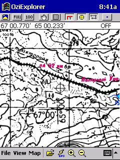
For software to work with raster maps and GPS-Pocket PC hardware shows full solidarity with the Palm. No suggestions. The only existing application - OziExplorer CE. By itself, OziExplorer CE impression of a very high quality product, with a lot of opportunities. In general, the way it is. However, among the many advanced features not, perhaps, the most basic: the possibility of binding maps of the terrain.
 |
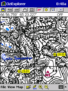 |
Scanned map is passed through a special converter, which prepares both herself and scaled up. For the user, this procedure is completely transparent, and when using Ozi transition to a different scale is very fast and convenient. Thus, the card is placed on the CF-card, configure the necessary ways (this should definitely read the documentation, all non-trivial) and ... nothing happens. Ozi offers to open only one. Map-file, not. Ozf2-file, which turned the original map converter. What's the matter? It turns out that OziExporer CE do not know how to attach and adjust the binding maps. Prepare them only in version OziExporer desktop, which costs money. A OziExporer CE only works perfectly with the already-bound cards. Work on the binding map requires some knowledge of geodesy. However, the problem is applied and fully mastered by many.In the networks have found a lot of theoretical and practical material, but the story about this is beyond the scope of the article. Subject of an interesting and worthy of study.
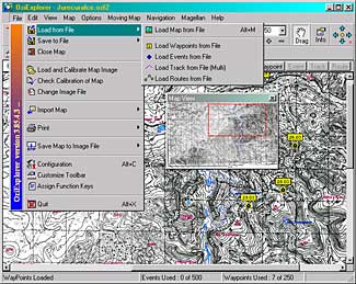 |
In the end, the map of the Polar Urals was tied to the available points on it with the values of latitude and longitude. Generally, there are many options for bindings. Most likely was not chosen the most correct of them, in connection we doubted performance Windows CE - a kit.
Paper GPS-Kit
Consisted of a GPS-receiver eTrex and notepad with pen. All indications of waypoints were entered in the notebook as you travel.
Packing
No special carrying cases at our disposal was not. Besides, it was interesting to find out the stability of devices to allow an external physical influences. The only precautions are standard protective film on the screen plus Silkyboard for Palm. All devices were neatly packed into a thin cardboard box, which for greater moisture protection pasted tape.
User
Honestly, was drawn up hastily, as the dates for the preparation of the expedition were pretty tough. Whether this statement in more detail may subsequently have been able to avoid several mistakes.
Conclusions (preparation):
Palm OS set seemed more suited to the tasks of GPS-navigation users with good skills to guide the application (that is just for tourists, sportsmen). Binding capability maps directly on the ground to avoid the study of the theory of making topographic maps. However, we must know exactly where you are at anchor, and also have some experience in dealing with both Palm, and GPS-enabled. Using a trained and properly attached maps for Pocket PC is very easy and intuitive. User Windows CE does not need to have extensive experience in guiding, but the procedure is binding maps on a desktop computer requires theoretical knowledge, as well as some experience on the use of OziExplorer. Windows CE-package is heavier and cumbersome. Thus, GPS-sets collected and prepared for two-week trip. Train Moscow-Labytnangy "kills four members of the campaign with riot gear in backpacks.
Appendix
Excerpt from the documentation of the project with a description of the main objectives and results of the training
The project has the following objectives:
- Explore the possibility of real application of GPS-systems in real conditions of the polar regions.
- Determine the degree of need and usefulness of GPS-complexes in the polar tundra.
- Develop a technology preparation of maps, to determine the degree of complexity of the process.
- Compare the GPS-complexes of different platforms: the ease of use, accurate readings, and reliability.
A list of requirements:
- Devices should as long as possible to work offline.
- The devices must be resistant.
- The software must support the loading of raster maps with location.
- The software must provide a link with a GPS-receivers and displays the data: the location on the map attached to the terrain, speed, current position, altitude, direction of movement.
List of equipment:
- Windows CE GPS-complex (total weight about 900 g)
- Cassiopeia E-125
- 48 MB Compact Flash storage cards
- GPS-Receiver Garmin eTrex
- Patch Cord
- 2 extra charged battery for Cassiopeia
- 2 extra sets of batteries for eTrex
- Software
- Ozi Explorer CE for PPC
- Ozi Explorer for PC
- Palm OS GPS-complex (total weight about 450 g.)
- Palm Vx
- GPS-receiver Rand McNally for Palm V series
- 2 extra sets of batteries for
- Software
- GPS Pilot Atlas
- GPS Pilot Cartographer
- NMEA Monitor
Windows CE benefits (in preparation of equipment):
- Color screen, color map.
- Placement of cartographic material on the CF-volatile memory card.
- Ability to replace power supplies as a PDA and a GPS-receiver.
- The ability to use GPS-receiver without connecting to a PDA.
Windows CE defects (in preparation of equipment):
- The need for a cable to connect the GPS-receiver and Cassiopeia.
- Overall a great mass of GPS-kit.
- High power consumption device.
Palm OS advantage (in preparation of equipment):
- The overall light weight GPS-kit.
- A long time PDA offline.
- Palm and GPS-receiver are connected together.
Palm OS flaws (in preparation of equipment):
- Inability to replace the batteries in the PDA.
- Screen with 16 shades of gray, no color map.
- GPS-receiver can be used without the CCP.
- All data is stored in memory and are not protected from loss.
Preparation of maps and software
Windows CE advantages:
- Color map
- Fast zooming
- Convenience interface OziExplorer
Windows CE disadvantages:
- Need for a thorough study of the principles of the topography, types of bindings cards, etc.
- Lack of tools to bind / bind correction maps in place directly on the Windows CE device.
- Snap cards implemented in software for desktop computers, which is worth the extra money.
- No built-in status display of GPS-receiver.
Palm OS benefits:
- Special knowledge of the topography is not required.
- Binding is carried out directly on the ground at two points.
- Converter card is free.
Palm OS disadvantages:
- Black and white map with shades of gray.
- Poorly designed interface Atlas, some operations is not trivial and can lead to unpleasant consequences.
- No built-in status display of GPS-receiver.
- Lack of scalability.
The authors, translation:

