In several previous articles you could meet PalmGIS - electronic map of Moscow, running on handheld computers running Windows CE and EPOC. Today, we conducted a small field trial: see what PalmGIS navigation capabilities in real conditions of the city. Let's try to pave a few routes and follow the movement of his car with satellite navigation GPS.
For these tests have the following equipment:
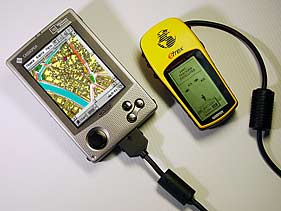
Basis Navigation System - Pocket PC Cassiopeia E-100 (Windows CE) with an installed electronic card PalmGIS GPS. By Cassiopeia via special cable connects the GPS-receiver Garmin eTrex. It determines the position of the object and sends them to a PDA. Signal processed by the program PalmGIS, and on-screen handheld point occurs, indicating the position of the car. So, let's begin. GPS-receiver - on a shelf under the front window, connect to it Pocket PC, run PalmGIS. While warming up the engine, enter a start or end of the route, and eTrex catches needed 4 satellites. Appears on the map purple point - this is our car. Let's go!
The first route - from Nikoloyamskaya street to Kolomna. Check the accuracy of GPS navigation PalmGIS
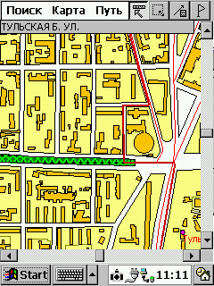
Purple dot moves along the red thread of the route - it is we are going to Moscow. Cross the Taganka area. Doubts arise at the end of the street B. Bricklayers - PalmGIS offers to go to the right and merge onto Simonovsky shaft on a side alley. Why - it is not clear, because the main road goes straight. This way we know well, so do not believe the map and go straight. A few minutes later once again go to the Route and in full agreement with it get to Kolomna, the benefit is a straight line. On the broad avenues of claims to PalmGIS virtually none. The accuracy is quite satisfactory - the deviation does not exceed 15-20 meters. Satellite signal is lost.
Now change the situation. We are moving to unfamiliar areas, and guided only information PalmGIS
In this situation, need an assistant, which monitors the movement of the vehicle on a map and warns of the bends. Watch the road and follow closely the card is practically impossible, then needed a voice interface. We go from Kolomna to Altufevskoe highway. Nagatinskaya street, turn right onto Varshavka ... Incident happened when the purple dot close to the area of Serpukhov outpost. Here the situation is repeated street Large Masons. Despite the existence of a direct passage to the street Mytnaya, PalmGIS invited to go further left, the Serpukhov shaft, and then get on the streets Mytnaya. Eksperimet is an experiment - we blindly obey the advice of the card.
 |
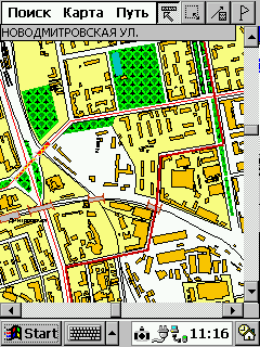
Conceding a stream of cars on the street Mytnaya, we go out on the yellow turned to the left. And in vain - the first right of way, which we have proposed to go, was entering the territory of the Danilov market closed iron gates. More or less the carriageway was only Havskaya Street, fourth (!) Right on the view PalmGIS. Having strayed on back streets Shabolovka Yakimanka instead we ended up on the Garden Ring. Frankly, the last chance to return to the route was lost due to negligence of the crew, not the fault of the card. PalmGIS regularly show our movement. Even in tunnels at the Garden Point continued to move, despite the short-term cessation of signals from satellites. As the old route we went, finally and irrevocably, with the Crimean bridge paving a new one. Now he is on the Garden Ring to the 1 st Brest street. As you know, Mayakovka Garden Ring dives into the tunnel, but we need to go right, up to Tver. PalmGIS shows that need to keep to the right, but the tunnel is not labeled - the situation is obvious. At junction before Savyolovsky Station we offer taxied to Novoslobodskaya street toward the center, then unfold. This way there.Perhaps he is shorter, but faster would be another way: through the tunnel to Suschevsky shaft. We're going into the tunnel - at the same time check, as the navigation system will behave in a long winding cave. Who knows - this tunnel describes a semi-circle, away from him to turn right and after 50 meters - right again, and soon enter a very broad bridge.
 |
As expected, the point for some time continued to move right, and then froze on the spot. Only about a minute and a half in GPS-receiver to understand: what is wrong, he had been deceived. However, immediately orient and showed the new location of the machine. The main surprise was waiting for us at the end of Butyrskaya street. PalmGIS proposed to cut corners and fly like unto a bird through the Savyolovsky railway before publishing "The Young Guards". Well, there are no moving! There is a boardwalk crossing the road, absolutely impassable for a car. Maybe in a jeep there proedesh ... Breaking a car we did not, and crossed the railway a little farther in the usual way, on overpasses. Then everything was like the truth, except the offer to go to the Ogorodny travel in the opposite lane. The signal from the satellite data was permanently lost only after entry into the yards Otradny. Domestic multi-storey box perfectly resists ingenious navigation systems of the West.
Third test: we were going out of town. Will PalmGIS useful in a suburban trip?
We go with Altufevkogo highway in the direction of Sergiev Posad. Point moves on the map, the deviation does not exceed 20-30m. Leave on Ring Road. With increasing speed, there is a feeling that the point a little behind the real machine. On the map are not designated traffic police posts and watching the camera - we need to expand the database:)) Departure for Yaroslavl highway - on the declining arc with two short tunnels. Navigation system, as usual, did not notice the lack of signal, and we drive in Mytishchi. Everything. Hence, the orientation of PalmGIS does not make sense. Yaroslavka on the map is not marked. Some surrounding facilities are available, but the farther - so they are fewer. After a while the point moves over the white desert. But we do not turn off PalmGIS - what happens when you exit overseas maps? Have to wait a long time - in fact PalmGIS included Zelenograd, but he is pretty north of Moscow. Well that's all. Point reached the edge of the map and got stuck. And after a few seconds disappeared altogether. Summary - in a suburban trip PalmGIS virtually useless.
Fourth test. Let us see how behaves PalmGIS in central Moscow. Wander a little on the streets.
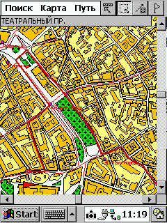
I will not fully describe our trip. I can only say that the desired structure on the street Pipe in the database was not, and the proposed path to a nearby house led us to the fence with a "brick", for which there was a building. I had to leave the car and walk about 100 meters. But on the way back PalmGIS completely rehabilitated, placing us in a roundabout way to the Garden Ring and saves you from standing on Sretenke.
 |
Distressed only work of navigation. There was a feeling that the GPS-receiver is constantly losing the signal. Point it stopped, then abruptly caught up with the car. And then completely stuck in one place. I thought that the signal interferes with dense buildings center. And the next day found out that Cassiopeia For unclear reasons, has failed connector that connects to the serial cable. That is, he just hung out in the nest, unable to provide any connection. Kasya had to pay for repairs, and the test result N4 invalidated. By restoring the device experiment will be repeated. Except for the failure of the navigation through the fault of the iron work PalmGIS can recognize quite decent. After spending a minute on a route on an electronic map, you can save 15 or more. And furthermore, if to the traffic situation and make a trip to Earl's own corrections. Paper atlas, in any case, we do not need.
To summarize
The navigation system really works. Small deviations, delays at the beginning of the movement and at bus stops, in my opinion, are forgivable. In the end, we used the GPS-receiver is very simple and the testimony of his very approximate. He is positioned as a GPS-receiver is an entry-level, intended for tourists, bikers, etc. But even this accuracy is quite enough for orienteering in the city, especially because the card is integrated opportunity override location. In tunnels and under bridges of any GPS-receiver loses its signal. However Tested Our model for some time after the loss of the signal continues to develop the movement in the same direction at the same speed, waiting for the resumption of the signal. So that the passage of bridges and tunnels, straight passes almost imperceptibly. The main problem - inconsistency route graph to the real situation on the road. I'm not surprised. According to the developer - the company Kiberso - PalmGIS graph uses data from the traffic police. That is, for the exact count is important good organization of the movement. How are we organized movement, we know. Therefore, the graph is the same accuracy. But even in this matter is not so bad, if you use an e-card with his head. I recommend to use the routing functions only to establish a common plan of motion. That is: to get from point A to point B, you need to pass on such a street. You can be sure that the proposed route is close to ideal. But the complex interchange of PalmGIS pass is not necessary. Firstly, it is easy to get lost, because you specify only the general direction of motion. Second, and the general direction indicated serious bugs. Another problem in finding the way: PalmGIS looking for the shortest path. But the best route may not coincide with the shortest! Direct way on lanes could easily be longer than a detour on the motorway. Do not forget about the state of the roads, the number of traffic lights, speed bumps and other such factors which PalmGIS, alas, does not account for. In general, the proposed road map should be treated creatively. If suddenly for no apparent reason are invited to leave the broad streets and, having strayed on back streets, back on the highway, then I recommend this question. Huge opportunities opens the manual editing of the graph. You can prevent a fare on a particular street or, conversely, to allow it. Refinement route graph is its actualization. From time to time such work should hold the developer of the system, but his ability is not limitless. Therefore, to help themselves. Perhaps some time will be able to automatically update the graph and send you information about traffic through the paging or short message SMS.
The overall conclusion after field tests:
The technique helps those who help themselves. PalmGIS-PalmGISom, GPS-GPS'om, and his head still think it is necessary. Information about the shortcomings of the program and manifested errors will be communicated to the developer PalmGIS - Kiberso firm. Request to all who noticed discrepancies in the PalmGIS, send them to the product description on our address: developers@maccentre.ru. The authors, translation:


