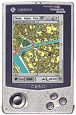
Recently, various computer magazines appear reviews on PDA, or PDA. All these reviews brings sorrow to the lack of original Russian software (software) for PDAs. In this article I would like to partially cover the status of software for PDAs and show that something in this direction in Russia is still being done. By virtue of their professional interests of the entire spectrum of software for PDAs I consider geographic information systems (GIS). Until recently, this sector of the labor market three firms: "Geocenter-Consulting", "Legislative Assembly High-Tech" and "Kiberso. But the first two companies have been developing for the platform Windows CE, and about a year ago, they even left the market software for PDAs. Therefore I will continue to consider software for PDAs firm Kiberso. Firm "Kiberso specializes in developing software based on GIS technologies. In this range of products extends from simple applications that implement the information and reference functions, and focused on normal users, to complex systems for professional work in organizations engaged in diverse activities: in the municipality and district administration, police department, traffic police, PSB, Civil Defense and Emergencies, Sanitary and Epidemic Control bodies, utilities, designing organizations, companies dealing with transport transport, etc. For PDA Firm Kiberso has developed an entire line of software products on the platform operating systems, Windows CE and Epoc 32 (device Psion). The information base for all GIS - Application is an electronic map of the city of Moscow, built on paper plates 1:10000 and regularly updated on the basis of aerial photographs. The electronic card contains a geometric description of all the homes, neighborhoods, green spaces, water bodies, centerlines of streets, railways, platforms, subway exits, bridges, fences. With the mapping objects are connected constantly replenished database of addresses, names of streets, urban infrastructure (pharmacies, banks, institutions, shops, restaurants, theaters, etc.). Basis for solving the routing graph is the route network, built on the basis of axial lines and streets are regularly updated with the information traffic police (one-way traffic, turning restrictions, repairs). Below presents a summary of commercial GIS - Applications firms commercially available software products.
PalmGIS, cost $ 30
This product is a lightweight and cheapest version of GIS. It implements options for viewing maps and information retrieval capabilities of the system. To view the PalmGIS provides an arsenal of tools. The system allows you to display in the map window an arbitrary set of available map layers with the ability to add, disconnect, and a reordering of the layers. The system allows you to customize the display settings for each layer, including color and line styles and fills, fonts, texts. Scaling, cutting a rectangular piece and scrolling maps are implemented using traditional tools (magnifying glass, rubber frame, scroll bars). Considerable interest is information retrieval capabilities PalmGIS. They allow you to take the help of objects under the cursor in obtaining information from databases, to mark the place on a map of named bookmarks and continue to use it for a quick search, address search to objects, to search for the object by name within a given category (restaurant, theater, Bank, etc.), look for objects in a circle of given radius, using a bookmark or center of the screen as the center of the circle.
PalmGIS +, cost $ 50
Having all the capabilities of the system PalmGIS, PalmGIS + provides the user with tools to develop the best routes of the car.The system allows you to select the starting point and the finish of the available methods to search for objects (to the address on the title, a bookmark) to pave the shortest route between these points on a graph embedded in the system of routing network traffic police based on information and possible traffic jams, view route on the map background, display the itinerary with a list of streets and showing the right turns and distances, without changing the points of start and finish paving the reverse route.
As the situation on the roads change quite rapidly, especially valuable is supplied with the system editor graph route network. It provides an opportunity to prohibit or authorize travel on separate sections of streets, denoted by the traditional place of origin of traffic jams.
PalmGISGPS, cost $ 100
In conjunction with the sensor of satellite navigation (GPS - receiver), the system allows you to display on a map location of the vehicle and track its movement on the map. Having all the capabilities of information retrieval system PalmGIS + PalmGISGPS allows you to easily navigate the city, get background information about the objects run the best routes to the changing road conditions. Additional system capabilities related to navigation include mapping the current position of the car a conventional sign, auto-tracking mode, in which the image of the car is kept in a visible part of the map and the chart automatically scrolls; correct geo-referencing maps of the current situation of the car. This is necessary because of the low accuracy location (100m), a sensor GPS civil applications. Such a correction can be performed even on the road, standing at the crossroads at the traffic lights. All the developed systems, but PalmGISGPS operate in a Windows CE or Epoc 32. Version PalmGISGPS for Epoc platform 32 is under construction. Any system can be installed either on the flash-card or in the file area of RAM and requires 8,5 to 10 MB of free disk space, depending on the version. To run the system should be 3.5 MB of RAM for programs. Presented in this paper, the system undoubtedly will prove useful to both individual users: tourists, motorists, businesses - in the car, home, office, and firms engaged in transportation of freight, delivering goods to the population, maintenance of cars on the line, ambulance, fire, police etc. The authors, translation:
