Briefly about the GPS system
GPS (Global Postioning System, code name - NAVSTAR) - satellite system, developed and maintained by the Ministry of Defense. Provides the ability to accurately determine its location on the earth's surface subscribers with GPS-receivers. When designing a system primarily meant, of course, its military uses, but domestic component of the application of GPS-navigation has become so popular that in May 2000. decision of the U.S. president had been cleared of all obstacles (called Selective Availability - selective access) that first deliberately introduced into evidence for the underestimation of the accuracy of satellite positioning household (not military) devices. Before this event, the accuracy of the receiver did not exceed + /-100m 95% of work time and only the remaining 5% of the time, the receiver is working at full capacity. " To the receiver can determine the coordinates, he obviously should be able to "see" the sky - that is, inside the system will not work. Modern receivers, as a rule, all 12-channel (ie, allow you to track up to 12 satellites simultaneously) and others have similar characteristics, differing mainly by the presence or absence of built-in mapping capabilities. The process of determining the coordinates of the receiver looks like this:
- when you turn on the receiver after a sufficiently long interval (so-called "cold start"), the receiver begins to receive signals from satellites and determine exactly which satellites from all groups are available from this location. Group of satellites that are visible at a given point called the "Almanac." After turning off the receiver, while keeping in mind the latest almanac in the case of reclosing after a short break, while fixing the receiver increases significantly (hot start).
- Receiver, receiving from satellites exact time (which last well synchronized with each other), the delays calculates the physical distance from them (the speed of propagation of radio waves is known). Having appeared in three or more satellites, the receiver, the method of triangulation is obviously an opportunity to determine their exact position in 2D-space. Having appeared in four or more satellites, the receiver can also determine the height and the subscriber above sea level, which, however, is calculated with a known higher accuracy than the coordinates on the earth's surface.
Obviously, the more satellites the receiver is able to interrogate and more spaced out, these satellites on the celestial hemisphere, the more accurate will be his testimony. At this time (after the abolition of the United States of SA), positioning accuracy ANY GPS-receivers under normal conditions is not more than 5-15 feet.
How to connect the GPS-receiver to the Palm (and what receivers can be connected)
Unfortunately, as a rule, mapping capabilities that can provide advanced GPS-receiver, are insufficient for a meaningful and easy to use all the opportunities that can provide the user system GPS. Especially frustrating situation with Russian maps, which are presented in receivers particularly poor. The possibility of the same load your own maps in most receivers are also missing due to the closure card formats almost all manufacturers of GPS-navigators, and for regular updates of existing maps can only dream about. Exit the author seems to be connected to the receiver of the independent predictive device, which will be able to perform these and many other useful features. It is obvious that under this article, such a device made by the CPC brand Palm. In order to implement a bunch of PalmGPS, you must first verify that your receiver has a serial port for connection to the computer (as a rule, many modern receivers have it) that the receiver is able to give the data using the protocol NMEA-0182, -0183 or EarthMate (proprietary protocol for their company DeLorme receivers of the same name EarthMate). To implement a physical connection is needed, obviously, a connector for the GPS-receiver, a connector for Palm'a and that's all it is necessary to build, given the characteristics of the contact wiring specific receiver and Palma.Way easier - as a rule, you can always get a cord to connect the receiver to the serial port (from the manufacturer or, if the receiver is the production of such well-known companies like Garmin, Magellan and some other third-party cables). Also, as a rule, is not difficult to get a cable for connection to a PC and Palm. When connecting these cables, you should not forget about the null-modem essence of both of the above cables as well as the fact that the final connection is Palm-GPS should also get a null modem (due to the fact that both Palm and GPS - the essence of DTE-device). Thus, besides these two cables, we also need a null modem adapter / cable, which we "deploy" one of them.
A detailed overview of the software (Atlas and Tracker from GPS-Pilot, HandMap of Evolutionary Software, TZ-GPS, NMEA Monitor) with the peculiarities of each
To work with GPS-receivers, the software that exists at the moment Platform Palm, can be divided into three categories:
- Software for raster maps
- Software to work with vector maps
- Utility software
Let's discuss each of the categories.
Software for raster maps
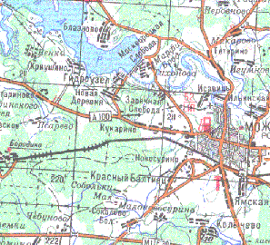
The choice is small - products company GPS-Pilot - Atlas, Tracker, Fly. In all three programs, maps downloaded program Cartographer (Fig. 1), which can be defined as a desired color derived maps and coordinates of the corner points of a convertible piece of card to bind her even when converting. If this is not done with the conversion, then after binding can be achieved even at Palm'e (two-point and direction to the north).
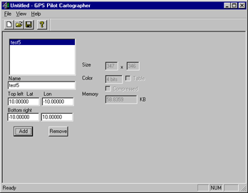 |
| GPS-Pilot Cartographer |
GPS-Atlas is designed for easy orientation on the map. As mentioned earlier, the raster map is converted to a format Atlasovsky program Cartographer. Location marked arrow on the screen, and the map with respect to the center moves. If you scan the same card in several scales, and to bind each of them, by pressing the scroll up / down Atlas will switch between the scales. This feature becomes extremely useful in the manufacture of, for example, a larger map of settlements, combined with small-scale road map of the area. Over the actual working screen, placed a service cap, showing the amount of "catch" the satellite, speed, scale maps, etc. The picture on the right shows another possible operation screen of this program, which displays in detail the speed, position, direction, altitude, etc. Immediately select the protocol that will communicate with the receiver and Atlas.
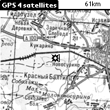 |
| The main working window |
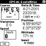 |
| Alternative operating window |
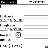
Below shows the settings Atlas'a (where, in particular, can put daw that Palm itself will not turn off when running Atlas), the screen defining a new "point"-a landmark, which can give the name and determine its coordinates (or get them from the receiver). These points will be displayed on the map and they are also necessary in case of linking maps on the fly - see Figure 7, which depicts the calibration process (tying cards) by two points.
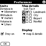 |
| Preferences window |
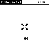 |
| Calibration |
GPS-Tracker Atlas'a differs from the first routing engine. Uploaded on Palm cards will be available in both applications at once. Settings screen calibration, identification of new points in both programs are also identical. The only difference - a permanent record of passable route, which then can be comfortably held in the opposite direction:).
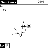 |
| Route:) |
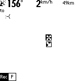 |
| Record in the process of motion |
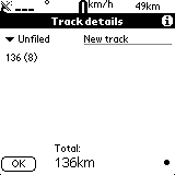 |
| Information about the route traveled by |
GPS-Fly - product specific and intended primarily for pilots of aircraft and other aircraft. As part of this article will not be considered.
Software to work with vector maps
At first glance, this choice a little more, but on closer examination it becomes clear that here we have to stop by just one product - a program HandMap of Evolutionary Software. The reason - the closed card formats in other programs and policies, in which maps are produced and sold solely by the developer. HandMap in this regard has a bit wiser - sold only shell, and the cards can do for yourself. In connection with what is already there at least two cards for Russian cities - Moscow and St. Petersburg. Fig. below shows a map of Moscow. The arrow shows the current location and direction of motion appears in the presence of module installed GPS-Tracker (which comes bundled Professinal version of this product). In the information box at the bottom of the screen displays speed, direction and altitude above sea level. Figure 12 shows the settings window. Figure 13 shows how you can find a particular street (or other) on the map. Unfortunately, the card format does not use international character sets, so that all object names typed in Latin.
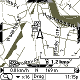 |
| Map of Moscow |
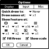 |
| Settings window HandMap |
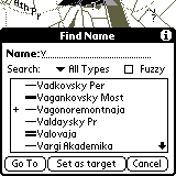 |
| Search for streets |
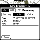 |
| Information from the receiver |
Utility software
Personally, I opted for two frivarnyh utility, which I quite actively used for navigation. The first utility is called TZ-GPS and the only of its function - the image of "heaven" with the fixed points of satellites, as well as information obtained from satellites - that is, the exact time of the calculated receiver coordinates, speed in knots:), etc. Handy when you start working with the system in order to understand exactly how many satellites to "catch" and when completed the process of fixing the receiver coordinates. The second tool - NMEA-Monitor is designed for display in real time throughout the performance information obtained from satellites in the on-line. Convenient to determine the reasons for too long, the process of finding satellites, etc.
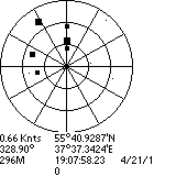 |
| Program TZ-GPS |
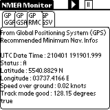 |
| NMEA-Monitor: coordinates, etc |
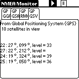 |
| NMEA-Monitor: Almanac |
Advantages and disadvantages of using this binder
Advantages: long battery life Palm'a and availability of sufficient quality thoughtful and worked a variety of software for GPS-navigation for this platform, makes this a bunch of almost perfect integrated solution. The absence of color seems an inconvenience at first glance, but due to this we are strongly committed to winning in the long battery life, small-scale maps obtained (a vector map of Moscow - only 200Kb), etc. Disadvantages: all the same absence of color, or rather a side effect of the lack of color screen: its liquid-crystalline structure makes it virtually impossible to continued work with the device in extreme cold - the screen freezes. Another problem is the same plan - an unpleasant job Li-Ion Battery (Palm V, Vx, Sony Clie, etc.) That's all the same cold. But, in principle, the constant use of GPS-navigation on the march and did not want to - so the device can be kept close to the body warm, and just get to see your current location or to note the next point on the route. Using the same ligament in the car or just warm, is the author of more than convenient.
Law
Technically, under current laws, using GPS-receivers in the territory of the Russian Federation, you have no right. For accuracy of determining the coordinates of the receiver should not exceed 100m. It is clear that these receivers do not exist, especially after May 2000. Those permits that are issued by firms such as Boston PiSi formally valid, can not be and if there are you seriously the claims of bodies, not save. To avoid foul language on this in the description of our legislation and integrity of the firm and I will stop. One good news - there are rumors, it's all in the near future showing more than would be canceled. And we will finally be able to use our devices freely. The authors, translation:

