Long ago, even while serving in the army, I saw a prototype GPS receiver, and immediately thought - I wish I was. It's so convenient - always know where you are ... That's just make this vision a reality prevented several things: it was not a real receiver - for positioning satellites are not used, and bind to areas implemented surveyors. Indicator was not at all. The path charted plotter directly on topographic maps. And the most sad - this «GPS» moved on wheels in the back of the GAZ-66, and held most of it. Later, there were these navigators, they cost like a car. And again, the dream remained a dream ... The prices are gradually falling, I often thought about buying a GPS-as well. But once I got into the hands of the magazine "Submarine", and I learned that there are Pocket PCs Palm. Thorny path of buying Palm-a, I reduced to phrases - "... I bought it."
 |
| So here you are, the reindeer! |
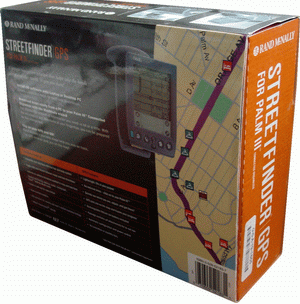
Desire to acquire GPS does not pass - I love fishing, hunting, or simply wander through the woods, and know where I currently am - a big plus. The more it became clear that the navigator can interbreed with the Palm-ohm, and as a result, track their movements on a map. On the Internet, I have chosen a Garmin eTrex, but in searching for them wandered into the device up for auction on the web, and spontaneously bought a crotch GPS for Palm IIIx. The name of this receiver - Rand McNally Street Finder, or for simplicity - StreetFinder. Brought me a box of volume, revealing that, I'm pleasantly surprised configuration.
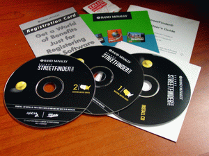 |
| Still Life: mukulatura, CDs, and alcohol swabs in the background ... |
- Strictly GPS
- Cover made of waterproof material
- Power Supply (with him was "ambush" - turned out to 110V)
- Mounting with suction cup on windshield car
- Any advertising trash
- Three disk. One software (inconvenient), but on the other two were maps of all states in the U.S. up to the street. The thing is extremely useful for Russia - for example, the disk can be supplied hot tea to not spoil the table ...
- The cable for charging from the cigarette lighter
- Alcohol swabs
For the most talented on the box is written: «Palm III connected organizer not included». That loosely translated to great and powerful means «Palm III not included. Reasonable warning, nothing to say.
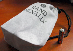 |
| Remember, in Soviet times there was a toy bag with a laugh "? Sound familiar? |
Try. The unit is firmly fixed on the Palm-e. Seeking GPS-power switch as well. Nope. Neudachka ... Remembering the wise adage: if all else fails, you must read the instructions, read the document. It turns out that it is automatically enabled when you start the GPS-Nogo software, and off two minutes after exiting the program. Decide to charge the battery and found an additional transformer is 220-110 V. Connect. Lit Zhovten'ka svetodiodik. After charging, the yellow color changed to green. Symbolic. You can go.
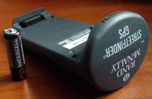 |
| No, no ...GPS works on its battery, AA battery shows the ratio of sizes. |
Taxi on the street, run the program. Waiting ... waiting ... waiting ... Figushki! «No GPS satellites received ...» turn off the entire economy. Mindful of two minutes, I do "efreytorsky gap" - waiting for ten minutes. Turn, makes me nervous. ... Everything! Order. "You have six satellites". For complacency decide to try again. Include, wait. Long wait ... Tee-shi-to. Virtually the entire day engaged in switching - off, trying to understand the pattern. Did not understand. Then immediately catches the satellites, for a long time is initialized, then nothing catches. Went to the 'Net, on Web, deep in the bowels of the site found a utility GPS Meter, showing the location of the satellites. Found that when periodically switching between GPS Meter and the program StreetFinder, then the consultation process is faster and more stable.
Personal impressions of the work in the field
Because the GPS I bought for incursions into the forest, at the first opportunity I had experienced in the field - as soon as the ice of the lake were opened, I took him fishing. Left out of the garage, stuck the suction cup on the windshield, wait for the initialization. GPS without problems fished 8 satellites. Let's go. They traveled long and hard - the snow melts, the terms of dirt, snow porridge, from a large amount of water swamps and lowlands "swollen". Part ride, part of the slow sailing. Average speed was approximately two and fifteen miles per hour. Oh, yes! Forgot to warn - I'm not so Bezbashenny to the marshes and mud to ride a normal car. We have two self-made "the beast" on the low-pressure chamber. That's on them and travel ...
 |
| "Bulkotryas, equipped with GPS-th ... Everybody hide! |
Oops ... a little distracted ... Already at the entrance to the lake GPS asleep - said the "Suspend", and all. To wake up and give it a sense of my time was not. Simply turned off the bunch. Upon arrival at the place turned to deal with it. Poltergeist some ... initialize properly showed the coordinates. Narybachilis, let's go back. Again, hang a bunch on lobovuhu. Run all this economy are determined. Everything is fine. Before reaching the garage a mile GPS again said "Suspend". Spat, did not bother with them. At the exit from the forest, as always, was in existence a chic pool - in akkurat at the place from start to grow legs, and long in good forty meters. I swim, not bothering anyone, suddenly corner of my eye I see how something gray swooping down. Reflexively grab. Turned out to be the navigator. But Palmu less fortunate - fell by Polycom, under the gas pedal. All, I think - in a crisis! Rather, I thought not, but the meaning of this ... - no doors, I like ice in the hole, hang out in the middle of the puddle, Palm under gazulkoy, add gas - crush the screen. Do not add - zaglohnu, and Palm shake the water fall.
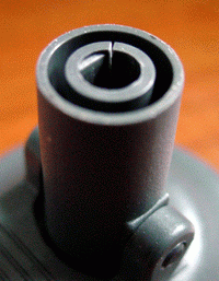 |
| Crack that learned to fly, Palm and GPS |
Do not worry, nothing happened. Left is normal. Gave a debriefing. It was found that the bursting of the bracket suction cup. The photograph is clearly visible.
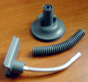 |
| Cheap and cheerful |
The very flexible design was simple as a swab - an aluminum rod with him dressed in a decorative "gut". Now here is a concern - to restore this economy, so that Palm did not fly away again ... Now, a few thoughts about nutrition GPS.I understand, of course, innovation, engineering thought, progress ... But tell me - what for Palm III, running on batteries have a navigator, powered by the battery? And what GPS, made for Palm V (which is powered by internal battery), built on batteries? Not logical to be done with GPS-powered s vice-versa? I thought about extra nutrition. Initially I wanted to parallel the internal battery output razemchik and nourish navigator from three batteries. However, solved the problem easier - pile marching charger.
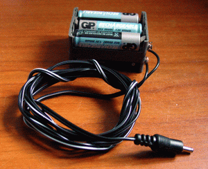 |
| Engineering marvel |
The design is very simple - six batteries in the external tape and wire, which I cut from the native-native StreetFinder-power supply. Anyway, he was 110V ... Moreover, for charging at home, I picked up the charger to the 220V. Charge current from a marching charger - about 120mA at 9V. The assumption of a sudden falling asleep Navigator: probably - got the battery from the cigarette lighter because I will not be fed, hoping to survive in their native diet. The argument in favor of this - a bunch of stuck on the balcony glass, connect an AC adapter, four hours he was there, I took it for the coordinates ... If I could just sleep ...
Now, about the maps and programs ...
Since the native program StreetFinder I was not satisfied, I bothered to search for decent software. Programs that work with vector maps are uninteresting to me, because detailed vector maps for our area, probably does not exist. Draw your own? There are easier ways to commit suicide. Therefore programs that work with vector maps, in this article, I will not be considered. Other programs that deserve attention, can be divided into three groups: support raster maps that do not support map display, and utilities that make life easier when working with GPS software.
Programs that support raster maps
In the first group a long time and is uniquely determined favorite - the company GPS Pilot, which released products such as Compass, Atlas, Tracker and Fly. In addition to these, the company issued and Windows-based Applications - Topographer, Cartographer, TrackExporter. Part of these programs, such as Fly (intended for private pilots, hang-gliders. In general, for those who fly), and Compass (a program with very narrow features - simply an electronic compass), I considered not going. Let's try to deal with the Atlas-th and Tracker-ohm. If you compare their interfaces, they will look like twins, except that the Tracker is able to draw the map to distance traveled. Accordingly, the menu item added "Track", in which the work of the routes. But in the Atlas-E is more convenient to organize the work with maps - choose the desired card, select the desired section of the map.
 |
| Atlas 5.05 |
Let's consider more in detail Atlas, as well as the Tracker is very similar to it, with it you can easily figure it out. Let's go ...
 |
| Set the type of receiver |
First things first, for completeness sensations connect GPS receiver to the Palm-y. Receiver Type put "NMEA". As a rule, all modern GPS-s communicate through this type of interface. If the title bar label "GPS not detected" was not lost, try the other types. In my case, except for "NMEA", the receiver has responded and the "Companion".If you have a GPS-and yet, either, for whatever reason you do not want it to connect, go to "Menu" - "GPS", and in the "Input" expose "No GPS". Then Atlas will be silent. Either put the regime "Simulation". In this mode itself Atlas will simulate the GPS receiver, even if its you he has never been, and thoughtfully to roam the map in all directions. In this mode, I do not recommend going on the terrain, guided by his instructions. Ivan Susanin just smokes nervously behind ... now would be nice to configure all the options, what we are going to do. Go to "Menu" - "Option" - "Preferences".
 |
| Setup screen option |
By default, all the units are installed in the American standard - a mile, feet, gallons. We correct all this facilities. Four check-box on the right show, will display icons on the map waypoints, cities, airports, navigational beacons (the latter is only useful to pilots). Unfortunately, their icons can not be added. Be sure to check "Stay on", otherwise after a while, just off Palm. With the settings sorted out. It's time cards. Who said "playing"? Tracker is able to work and fiber cards. That is: if the same card to keep with the different sizes, and link all the instances to the same coordinates, if you change the map scale "iron" buttons "up and down" will be shown a copy card. Here's how it looks:
 |
| The largest scale. Size of the original image horizontally - 1000DPI |
 |
| Medium scale. Size of the original image horizontally - 500DPI |
 |
| The smallest scale. Size of the original image horizontally - 200DPI |
Came time to look at the process of creation and conversion charts. Site www.gpspilot.com take a free utility GPS Pilot Cartographer, extract it to any folder on your computer. Run until we are. Not yet. Now, any available method, we obtain (scan, photograph electronic camera, draw by hand) an electronic version of the topographical map. Resolution - 300 DPI. Then I did: drove her in ACDSee, and means to change the sizes. Original size - 1000h892 pix, then reduced to 500h446, a third option - 200h178. All options have been saved as 1000.BMP, 500.BMP, 200.BMP with the number of colors - 256. And now run Cartographer ...
 |
| Operating window Cartographer |
Click "Add" button and fed him our 1000.BMP. In response Cartographer begins to pry on the subject of many shades of gray to get the output and compress the base or not, but the device can be colored? Since I have a Palm IIIx with PalmOS 4.1, I have this:
 |
| The choice of conversion options |
That is convenient, Cartographer, immediately shows the estimated size of the base. Click "OK". The turn of a map to the area. If you have accurate maps of gridded, then you can just specify the coordinates. I prefer to tie directly into the card Atlas-E.
 |
| Box-binding Cards |
Enter (or enter) the coordinates, click "OK". In the window above the button "Add" came our Burn source and neatly chopped in pyataks card. Reserve base: "File" - "Save As". Obzovem its 1000.PDB. We perform the same manipulation of files and 500.BMP 200.BMP. In the end we got three PDB file, which is and must be downloaded to Palm. Loading ... downloaded? Hmm. As quickly. Maybe Palm USB-shny ... To Tracker saw and showed our cards, let's connect them: "Menu" - "Map" - "List":
 |
| Hooking up the downloaded map |
 |
| Select the target site |
Choose the most detailed layer - 1000. The topmost piece - is the upper left corner of the map. The last digit in the designation indicates the horizontal, on which this part of the map is: 0 - top row, 1 - second row from the top, etc. Penultimate figure - is the number of horizontally. The countdown starts from left to right, the numbering goes from "0". We choose for example the upper left corner - cut2560-0 (cut256 - this I had called the card, do not pay attention). Well, the map on the screen is present. Now Tie it to the area because of non-tied card can go away for a long time. There are two possible scenario: if you have the physical ability to get to the conspicuous points marked on the map, it's just wonderful. But if not, the card will either bind at the stage of conversion, or on arrival, arrival, arriving at the place marked on the map.
 |
| Card is selected |
To bind you need two points with accurate coordinates. Moreover, the farther they are apart from each other, the better the binding. I put the point straight out of the car while driving on a fishing trip - at one intersection first, the second - the second one. Previously, just fire when leaving the house was determined with the coordinates and put another one spare point. So you do not forget, I once had called the point of his - "dom", pere1 "and" pere2 ".
| Programs, utilities, impressions "width =" 160 "height =" 160 "/> |
| The first and second points for the binding |
 |
| Third, a spare point |
The points are ready. Wonderful. Go to "Menu" - "Calibrate". Atlas asks us to specify the first point for calibration. Stylus pulls up a map so that the desired location was directly under the crosshair. For accuracy, we can just once click "Up". Map zoom in, however, with rasplyvetsya due to interpolation. Not fatal. Anchor point to be seen. Put space resection under the crosshairs? Click on it. Select the desired point ("pere1"). In the same way indicate the second point. If the points are on different screens, zoom, otherwise you will watch a bug - the one piece of map that has been behind the screen, not is rendered. Sometimes it may be that the map on the screen is not visible. Well ... People we are not proud, put it forcibly. Go to "Menu" - "Map" - "List", and the arrangement of squares prikinuv card, select the desired piece. Next to bind, as described above. Basics now you know. Let's go through those menu items that I have not touched on above. "Menu" - "GPS" - "Details". Partly, I already talked about this menu, I'll tell in detail.
 |
| Screen GPS |
A little digression. As I wrote at the beginning, the firm has a program GPSPilot Compass. This screen - it is. More in the Compass-e nothing. Rundown now on "Menu" - "Options" - "Database".
 |
| Database points (top) and maps (bottom) and the establishment of its base points |
As you can see, almost nothing tricky ... The top of the indicated number of points noted at the bottom - podgruzhennye card. There really is one small nyuansik - if you select a base point, and then click "New", it will create a new database of points of another type. You will be asked your name, and what type would be the point in this base - travel, airports, cities, driving beacons. Now, when marking a new point you will have a choice - what type to put the icon. So we came up to mark and edit waypoints. There are two ways to mark a new point. Click on the crosshair on the screen. Appears on "Center". Clicking on the link, you can create a new one, or move to the center of the screen map to an existing point. When selecting an existing point, it moves to the center of the screen, but if you create a new one, you will need to enter the name of point and click "New". In the next dialog box, you will be offered to introduce more detailed information. And rightly so. Over time, man has the ability to forget. Better just to write - "Halt" than half a year to remember - "... here I either came in bearish waste, or lost a backpack with food."
 |
| Screen marking points |
1 - Name of the point. The default is the time and date mark.
2 - Short title points.No more than eight characters.
3 - A detailed description of the point.
4 - If you previously called dialogue marks a point, then, at the right time by clicking on this icon, you upgrade to the current coordinates.
5 - Select the database to store the point and, accordingly, to display the icons on the map. Now this is the point of airports.
 |
| Field properties of a new point |
The second way to select a point: click on the "iron" button "Notebook" is the same dialogue. If you need to edit an existing point, you must do the following movements: click on the marker, press the "Center", select a point that needs to be corrected, the map from this point moves to the center, once again click on the marker, only this time do not have to choose " Center ", a point name. In the opened window with the data of the active point to press "Menu" - "Edit". Voila! Edit ... awkward? And who is now easy!
 |
| Management of the program by pressing the Palm-a |
Working with the program by pressing the Palm-a:
1 - not used. At least there was no response when you click on it there. In the original document - also a word.
2 - Show / hide the properties screen GPS.
3 - Increase / decrease the scale.
4 - Zooming. The program allows user to remember two scales (on the screen to the right-bottom of the numbers 1 or 2) and panorama mode (on the screen - a symbol of a magnifying glass). At the moment map is shown in the second user level. If the card is laminated, next to the scale icon appears in the "hands up and down." If you select "custom scale and with the help of these arrows to set desired, the Atlas will remember him. In the same way and the second user selected scale. This button switches on the ring "User 1" - "Custom - 2" - "Panorama".
5 - marking a new point. The first press calls a dialogue marking the second - actually marks the spot. Sufficiently important in the movement - nastrelyal points, and then, in a calm atmosphere deal with them properly. Well ... It seems to Atlas-nd we're done. Take up the Tracker? Since the vast majority of functions in the same program, dismantling a Tracker-th will be much shorter. With respect to Atlas-and this program has another menu item - "Track".
 |
| Menu Tracker 5.05 |
Go over the points from the top down diagonally.
List - a list of routes. It also creates a new route. I do not know what guided the developers, but the menu, you can either select an existing path or create a new one by selecting the desired category or create your own. By default, the route is called "New track", and rename it impossible. Or rather, perhaps, but "through the back" - you need to create a new route by clicking on "New", at what menu you are automatically thrown out. Then you need to go back a menu, select "Details", and here there is already assigned to the name. Why so complicated?
Record / Stop - can I will not comment? Pause / Resume - pause / resume recording.
Details - And here is a tool for changing the route name.It also displays the mileage traveled with start recording path.
Delete - Delete the route. Something tells me that the items "List", "Details" and "Delete" could rake in a heap without much harm to others ... a little different with the Atlas-th and the menu "Map" - There was an option "Best fit" ( "The best kind"). Attempts to fit on the screen the entire route traversed. The remaining items have not changed. Slightly redesigned on-screen interface: a menu marker add one more - "Set 'to'" - set the destination.
 |
| The new menu item |
In the upper left corner there was additional information - course for a destination, delete from it, the approximate time of arrival at a point at a given instant speed. Clicking on the arrow indicating the direction to the destination, we will see another menu:
 |
| Additional information about the destination |
Details - information about the destination.
Replace - Change the destination.
Show / Hide - Hide / show direction and other information. Hidden pointer to easily extract the light of day by clicking the stylus in the place where it should be - in the upper left corner. Here, perhaps, and all differences from the Atlas-a. But the result of my trip into the woods to start recording a route.
 |
| Track my fishing trip |
NDA-c ... It is not very good. If you look closely, above the red line procherchen my way. See where the path is outlined with a red circle, he crosses the lake. I have not crossed the lake. This is the result of careless binding maps. For information: Map - kilometrovka, each square - 2 km. Later, I recalibrated the map on that same third point, which is put in reserve at the exit from the house - I replaced it a point "pere1".
Slight digression
And the Tracker and Atlas - brainchild of one firm, it is not surprising that they use the same database. That I'm going to that card to bind better in the Atlas-E. Process is not an example of easier and faster. In the Tracker-e binding will appear automatically. In addition, both programs common database waypoints, which represents some comfort.
Programs that do not support map display
In addition to programs on the GPS Pilot programs exist to work with the navigators and other firms. Their fundamental difference - do not know how to work with the cards. This is of course negative. But the memory and Palm-and eat off an order of magnitude smaller. Of the programs of this class I can identify Cetus GPS and NavCompanion of Magellan.
Cetus GPS
 |
| Work screen Cetus GPS |
At the moment, released version 1.1b11. Freeware. Does not work with the card. That's bad. But the place is only 79 kilobytes. That's good. Other functions are available.That is:
- Displays the current coordinates
- Direction of travel
- Altitude
- Distance to destination
- The location and signal strength of satellites
- Power and battery Palm-
- Passed the way
- Travel Time
- Time and date (I would be surprised if it did not show)
- Minimum and maximum recorded altitude
- Average and maximum speed
- Marks the control points and save them in Memo
- Log is traversed path, and at specified intervals, stores it in the application MemoPad. Archives and transfers recorded logs on a large computer
- Ability to mark key points. True, not very convenient - the coordinates to be entered Tsiferki. However, there is a button "Here", which allows you to substitute the current position as the destination. If you mushroom hunter, fisherman, hunter - is the most it. What the [censored] start a program with a map display, if the problem is the maximum - to go back where you came from? But here everything is simple - at the entrance to the forest set point ("Menu" - "Navi" - "Set destination" - "Here"), and go to his legs carrying ... walk up, go back to the arrow. Comfortable? Of course! Cunning in the program there is nothing, but still we analyze it "on the bones." To begin with Cetus prepare for work - set it up, but at the same time and we will understand that for anything. Go to the installation of the program: "Menu" - "Options" - "Preferences".
 |
| Options Cetus-a |
- GPS serial port - from which port will work. Supports standard port, and GPS-s, which are placed in compartments of the external memory.
- Baudrate - speed of communication with the navigator.
- GPS init - initialize a receiver.
- Satellite fix - to question whether the satellites.
- Local time - set the time zone relative to Greenwich Mean Time.
- Sync time - whether to synchronize the internal clock of Palm-and on time, transferred from the satellite.
- Stay on - Making the Palm does not turn off when idle.
- Show sat - show satellites.
- Show HDOP - See correction accuracy (for Russia this is not true. As far as I know, the country of such stations do not. They and the "behind the hill" is not very much. It is a pity. Good Thing - When the mode of positioning accuracy increases to 2 - 3 meters).
- Alarm sound - Warn if an audible signal.
- Fix sound - a sound when determining the origin.
 |
| Installation of metric units |
Tack ... Now we must put the units ... Come on: "Menu" - "Options" - "Units" and expose the metric system. Configured. Now get down to the program itself. Cetus GPS work screen cycle through the "iron" button "DateBook": "Navigate" - "Position" - "Track" - "GPS". The main working screen.
 |
| Operating window |
In addition to the actual direction and the current positions of the following information: speed, direction, altitude above sea level, the amendment DGPS, the last location.Palm-buttons and the up-down "you can change the output in the bottom two fields: the amendment DGPS, the last location -" the length of the trip distance and travel time -> direction on the last point, the distance to it - "the maximum speed, average speed - > minimum altitude, maximum height -> time, date. Various options for this mode can be set here: "Menu" - "Navi" - "Preferences".
 |
| Options Navigation |
Mode Options "Navigation":
- Fix loss delay - delay in determining the loss of satellites. Time after signal loss, which the program will assume that the satellites are still determined.
- High precision - high accuracy.
- Speed stats - stats speed.
- Altitude stats - Statistics of height.
Screen mark the points
 |
| Note the new location |
Here are all familiar with the previous programs, except that in addition to the button "Average". Literally translated as "average." It serves to average the determination of coordinates for a certain number of measurements. The amount will be displayed on the screen after clicking on the "Average". Once you hit "Save", the program will summarize the coordinates, and divide the sum by the number of measurements. Simply put - calculates the arithmetic mean, and record the coordinates of the point. Very urgent thing is to get its coordinates in the movement since the instantaneous determination of the motion may not be accurate. Configuration mode "Position" can (and should) be "spinning" like this: pass or click "DateBook", or by selecting the on-screen mode "Position" and the path of "menu" - "Pos" - "Preferences" get to the settings. What's interesting about it?
 |
| Options marker points |
- "Save to" - to back up the point - either in the application "Memo", or the clipboard.
- Format as - log file format: GPX (on this score can not say anything - I do not know the format), Linefeed (newline), Comma (comma), Tab (tab), Semicolon (semicolon). Accordingly, your data will be read without problems by the same OziExplorer-surfing on a big car, and Excel files with different separators understand without problems.
- Data - in what form to submit data - in text form or in numeric format.
- Include - what data to include in the log file: The name of the point (Name), a description of the point (Text), height (Altitude), the date and time (Date & time), information on satellites (Satellites), the correction accuracy (HDOP) and statistics.
Screen record route
Here, quite simple. Push the "Start", write the name of the file, its short description, select the frequency of writing: write everything (All positions), only in the movement (Movements), with some frequency (Every ...).
 |
| Ready to record a new route |
If the record route is disabled, the top line will read "idle" - relax, do not write. The remaining lines - are empty.If the same log on, there will be the number of entries (Tracking), the time elapsed since the beginning of recording (Time), in which write mode - continuous, but in motion, every ... seconds (Save), in which file write (File ), the size of the file (Size), how much memory is available to us for the file (Memory).
GPS mode
 |
| Screen GPS |
Mapping satellites and information about them. Operating in this mode, Cetus tell and show you the number of captured satellites, the signal strength from each of them, the location of satellites, their numbers, the type of browser that is connected to a Palm-y, and the supply voltage Palmovskih batteries. That's probably all that concerns the program Cetus GPS. As you can see, the program will not complicated and easy to use. At its Palme I ask her to Flash. So, just in case ...
NavCompanion
... The second and final program of this group.
 |
| Menu Tracker 5.05 |
To be precise, the last program of this class in my review. Unlike the previous, Companion is able to draw the traversed path. But, as Cetus, can not work with the card. Conclusion of various data on the screen makes it easy than the previous program. And the interface is somewhat similar to Garmin GPS12. Here's a look:
 |
| An example of the work screen |
Let's see what can this program. Run ... At initialization time we show zastavochka. In the upper left corner there are the letters "RU". Attention to them until you pay. I have translated the interface into the Russian language, but without making a copy of the insurance, one careless movement Steele has posted all their work to oblivion. Translate later.
 |
| Why not GPS-12? |
Yes, I'm a little distracted. After initialization, you will be asked to indicate their location. You can specify, you can not. The date and time zone is not forbidden to specify in the options.
 |
| Specify the map to your location ... |
Traditionally, in the first place, we go into the settings: "Menu" - "Options" - "Preferences". NDA ... Bednovatye settings, frankly ...
 |
| Options Companion |
Well nothing is enough for these. Everything. We are ready to work - or rather, to the more dense the study. The program has seven modes of operation. Select the mode you can either Palmovymi the up - down ", or choose from the drop-down menu at the top right corner of the screen. Let's select "Status". At the same time and see how many satellites discovered the GPS, and some of them chose to determine the origin.
 |
| Monitoring satellites |
As a screen shot made with the emulator, the location of satellites and signal strength of each of them we will not see. Okay, try to explain in words. In the lower two rows (where the dashes) will show numbers of satellites, and over them - the signal strength. The higher the bar has risen, the stronger the signal. After interviewing all the satellites the inscription "No fix" at the top of the screen will change to "2D" or "3D", and number three, or, respectively, four satellites will be allocated - on a black background white numerals. You guessed correctly! It is for these three / four and will be determined by the coordinates. In normal mode positioning occurs by signals from four satellites, one of which helps determine the height above sea level ("3D"). But sometimes such that an acceptable signal can be given only three satellites (in the city, part of the horizon is closed or the subject of how, in a dense forest, under a heavy cloud cover). Then the GPS goes into operation from three satellites ("2D"), albeit with a loss in precision positioning. We assume that the coordinates we figured out the signal strength is normal, the reception goes into the "3D". By and large, we can already begin to move, but to know where to go, should be put a checkpoint. Switches to the "Waypoints":
 |
| I warn you - the point of abstract:) |
Two points have already been delivered (do not take them seriously. I'm not so bad that for some vodka to go with GPS'om). We press "New", in the resulting window, give the name of a point, write a description, put a checkbox in the check-box (which means - the point is visible on the screen). All, "Done" ... Now is the time to switch to the "Plot" and start a movement:
 |
| In this mode, the motion will be drawn on the traversed path |
As long as we go into the wide world, let's see what benefit can be derived from data on the screen. Top (picture above) there are three drop-down list, you can use to customize the display of relevant information, means a lot. And so in all three lists. In other words - this screen can be configured as a darling please. Can I just give translation of menu items? Nothing incomprehensible there. Except that the abbreviation of TTG. Then I - pass. Documentation for the program not as a class in the help, too, nothing is written.
 |
| The first part of the settings |
Latitude - Latitude
Longitude - Longitude
Elevation - Elevation
Heading - The direction of motion (degrees)
Bearing - The direction to the current point (in degrees)
Turn - the discrepancy with the current rate (in degrees)
Speed - Speed
| Programs, utilities, impressions "width =" 160 "height =" 160 "/> |
| The second part of the settings |
Avg speed - Average speed
Max speed - Maximum speed
ETA - Estimated Time of Arrival
TTG -???
Distance - The distance to the mark
Odo - Total distance
Trip odo - Distance
Trip time - elapsed time
Last fix - The last time positioning
Bat level - on how many hours and minutes remaining battery life (actual only for Magellanovskih receivers)
Bat max - Do not worry - Magellan GPS only
Date - Strangely enough - the current date
Time - Current time
UTC - Universal Time (UTC)
Blank - no output At the bottom of the screen: the left is the zoom scale were drawn towards the right - the display mode of the track. "North up" - north at the top; "Track up" - way up; "Course up" - the direction of movement at the top. Not be amiss to mention, and "Menu" - "Plot" - "Recenter map". After this command the active point moves to the center of the map. And another very convenient mode - "Menu" - "Plot" - "Enable / Disable panning". Enabling and Disabling pan traversed path. In the off mode ("Disable") a place where you are, there will always be in the center of the map. And in the on mode ("Enable") you can stylus to move the map around the screen. Move on to the screen "Speed":
 |
| If your car has broken speedometer ... |
Having said that, nothing new here. All familiar. How to forget? Run back to the previous page! The same custom indicators, trip meter, and distance traveled ... Is that - is not clear on the point scale. Do not break my head - a point noted the maximum speed reached. A little lying. True, I do not know who. Or GPS, or a speedometer on the Mercedes 290. The difference of 4 km / h. With the victory of a GPS-screen ... "Nav2". Here you can set the parameters that are like and need, but on the main screen - not really. Translation falling menyushek I gave above.
 |
| Menu Tracker 5.05 |
Of points ever labeled you can get a good route to travel. We collect the scattered points in one slim route: enters the "Routes", click "New". Our services all the preset points. Select them in the correct sequence from top to bottom. In addition, you can still add points by clicking "New". All the points raised? Click "Done". The route is ready. Now, in the "Plot", we can specify the "Activate route", a new menu to choose your route, and the instructions of the intelligent computer to go on this path ... Create a route you can view in the "Routes":
 |
| List of routes |
Ufff. With programs like finished ... Or not? If anything is unclear, write. Coordinates at the bottom of the article. Proceed to the third group ...
Utilities for GPS
Of this group, I highlight two utilities - NMEA Monitor and TZ GPS.
NMEA Monitor
Very comfortable, and very obscure program. Displays the service information from satellites. Many are not very clear tabs with different acronyms. Unfortunately, at this time to Palm GPS is not attached, and without utility refuses to work.The fingers can not explain that on one tab shows signal from the satellites and their location on the second - the raw data received from satellites - the third mode (2D/3D), number of satellites used for navigation, for the fourth - the exact coordinates, the state currently in (the norm or a warning about the impossibility of) speed, the magnetic declination.
TZ GPS
Simple utility. Even describe nothing ... Knows how to show only the sky map with the location of satellites and coordinates. You do not see how the class ... Now they have lost relevance utility ... At the moment, at least two programs are able to display the location and strength of the signal from satellites - is CetusGPS and NavCompanion. In the bulk of these small "pomogalki" I used to make sure that the satellites are "caught" normal. Once they showed that the signal is received properly, I switched to a working program - Tracker, Atlas, CetusGPS (in the version he still could not skip the "catch" the satellites), and continued to operate fully.
A few words in conclusion or disclaimer
- In order to enable you to quickly learn and choose the desired program, I tried as fully as possible to develop a theme. If someone is my article seem too detailed, then I apologize. First of all, I was guided by novice users.
- Perhaps the description of the programs I have some moments and missed ... This variant is quite probable, since the majority of programs do not have documentation.
- Since the school I taught German, taught him so many years ago, but in English I speak with a pure accent Ryazan, the ceremony could correctly translate some terms. Hopefully, common sense is not lost.
- I had the idea to expand on the work of Palma with external GPS receiver (Garmin 12, Garmin eTrex, etc.), but there I have none. Opportunity to take such aggregates for testing either, because in our town there are no stores selling such equipment. Had to abandon that idea.
- If you find an error, inaccuracy, you want to express an opinion or wish to comment on the article - write to me. (Or even better - speak out in our conference - NPC.ru) The authors, translation:
Igor


